


وصف لـ Garmin Explore™
Map, Track, Sync, and Share Your Trek From Anywhere
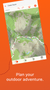
For adventure seekers, explorers and outdoor enthusiasts, the Garmin Explore ecosystem offers a complete mobile navigation solution that — when paired with compatible Garmin devices1 — lets you map, track and navigate your trek from anywhere with unlimited cloud storage.
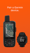
Garmin Explore provides basic trip planning or viewing of maps you’ve preloaded on your device. Or you can use the mobile app to pair your smart device via Bluetooth® technology2 with a compatible Garmin GPS device1, so you can do and see even more.
Access Online Connectivity
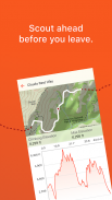
Garmin Explore provides free online access to a wide range of additional capabilities. For example, you can download detailed topographic maps, color aerial imagery and other navigation aids directly to your mobile device. The maps and navigation data loaded onto your device can be used anywhere, anytime — even when you’re out beyond the reach of cellphone towers or internet connections.
Organize Your Data with Collections
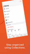
Review and edit your waypoints, tracks, routes, and activities in your library. Add them to a collection to keep all the recorded data from a certain trip together in one place. For example, if you’re taking a long trip, you can plan different waypoints, tracks and routes for each day of the trip and combine them into one collection.
Your Mobile Cloud Connection
The Garmin Explore app will send and store the waypoints, planned routes, GPS tracks and Garmin activities you've recorded in the cloud, allowing you to access and use that data on the Garmin Explore web site to plan or review your adventures. You can also sync your cloud-stored data with a compatible Garmin device. A Garmin account is needed to store your data in the cloud. Your activities (e.g., runs, walks, hikes, etc.) include data such as distance, pace, activity time, location, etc. that were recorded by your device.
More Off-grid Capability with inReach® Technology
Use Garmin Explore with your inReach enabled devices, such as the GPSMAP® 66i navigator and satellite communicator, to turn your mobile device into a true off-the-grid satellite companion. In an emergency, you can trigger an interactive SOS to the GEOS 24/7 emergency response team. Two-way messaging and LiveTrack location tracking via the 100% global Iridium® satellite network let you stay in contact globally. The Garmin Explore app allows you to access your phone’s contact list for easier messaging and sharing when connected.
What You Get with Garmin Explore
• Unlimited map downloads; access topographic maps, USGS quad sheets and more
• Aerial imagery
• Waypoints, tracking and route navigation
• High-detail GPS trip logging and location sharing
• Unlimited cloud storage of routes, waypoints, tracks, and activities
• Online trip planning
1 explore.garmin.com/appcompatibility
2 explore.garmin.com/bluetoothrequirements
The Bluetooth word mark and logos are registered trademarks owned by Bluetooth SIG, Inc. and any use of such marks by Garmin is under license.
تعيين وتتبع ومزامنة ومشاركة رحلتك من أي مكان
بالنسبة إلى الباحثين عن المغامرة والمستكشفين وعشاق الهواء الطلق ، يوفر نظام Garmin Explore البيئي حلاً كاملاً للملاحة عبر الجوال & # 8212؛ عند الاقتران بأجهزة Garmin المتوافقة 1 & # 8212؛ يتيح لك تعيين وتتبع والتنقل في رحلتك من أي مكان من خلال مساحة تخزين سحابية غير محدودة
يوفر Garmin Explore التخطيط الأساسي للرحلة أو عرض الخرائط التي قمت بتحميلها مسبقًا على جهازك. أو يمكنك استخدام تطبيق الجوّال لإقران جهازك الذكي عبر Bluetooth & reg؛ تقنية 2 مع جهاز Garmin GPS متوافق 1 ، بحيث يمكنك القيام به ورؤية المزيد.
الوصول إلى الاتصال عبر الإنترنت
يوفر Garmin Explore وصولًا مجانيًا عبر الإنترنت إلى مجموعة واسعة من القدرات الإضافية. على سبيل المثال ، يمكنك تنزيل خرائط طبوغرافية مفصلة وصور جوية ملونة وأدوات مساعدة أخرى للتنقل مباشرةً إلى جهازك المحمول. يمكن استخدام الخرائط وبيانات التنقل المحملة على جهازك في أي مكان وفي أي وقت & # 8212؛ حتى عندما تكون خارج نطاق أبراج الهواتف المحمولة أو اتصالات الإنترنت.
تنظيم بياناتك باستخدام مجموعات
راجع وتعديل نقاط الطريق والمسارات والطرق والأنشطة في مكتبتك. إضافتها إلى مجموعة للحفاظ على جميع البيانات المسجلة من رحلة معينة في مكان واحد. على سبيل المثال ، إذا كنت تقوم برحلة طويلة ، فيمكنك تخطيط نقاط طريق ومسارات وطرق مختلفة لكل يوم من الرحلة ودمجها في مجموعة واحدة.
اتصال Cloud Cloud الخاص بك
سيقوم تطبيق Garmin Explore بإرسال وتخزين نقاط الطريق والطرق المخطط لها ومسارات GPS وأنشطة Garmin التي سجلتها في السحابة ، مما يتيح لك الوصول إلى واستخدامها تلك البيانات على موقع Garmin Explore لتخطيط مغامراتك أو مراجعتها. يمكنك أيضًا مزامنة البيانات المخزنة في السحاب مع جهاز Garmin متوافق. هناك حاجة إلى حساب Garmin لتخزين البيانات الخاصة بك في السحابة. تتضمن أنشطتك (على سبيل المثال ، الركض ، والمشي ، والمشي لمسافات طويلة ، وما إلى ذلك) بيانات مثل المسافة والسرعة ووقت النشاط والموقع ، إلخ ، التي تم تسجيلها بواسطة جهازك.
مزيد من القدرة خارج الشبكة باستخدام inReach & reg؛ التكنولوجيا
استخدم Garmin Explore مع أجهزتك الممكنة في الوصول ، مثل GPSMAP & reg؛ 66i المستكشف والاتصال بالأقمار الصناعية ، لتحويل جهازك المحمول إلى رفيق القمر الصناعي الحقيقي خارج الشبكة. في حالة الطوارئ ، يمكنك تشغيل SOS تفاعلي لفريق الاستجابة للطوارئ GEOS 24/7. الرسائل ثنائية الاتجاه وتتبع موقع LiveTrack عبر خدمة Iridium & reg؛ العالمية بنسبة 100٪ شبكة الأقمار الصناعية تتيح لك البقاء على اتصال على مستوى العالم. يتيح لك تطبيق Garmin Explore الوصول إلى قائمة جهات اتصال هاتفك لتسهيل المراسلة والمشاركة عند الاتصال.
ما تحصل عليه مع Garmin Explore
والثور؛ تنزيلات خريطة غير محدودة ؛ يمكنك الوصول إلى الخرائط الطبوغرافية وأوراق USGS الرباعية والمزيد
والثور؛ الصور الجوية
والثور؛ نقاط الطريق ، وتتبع الملاحة الطريق
والثور؛ تسجيل رحلة GPS عالي التفاصيل ومشاركة الموقع
والثور؛ تخزين سحابي غير محدود للطرق ونقاط الطرق والمسارات والأنشطة
والثور؛ تخطيط رحلة عبر الإنترنت
1 Explore.garmin.com/appcompatibility
2 Explore.garmin.com/bluetoothrequirements
علامة Bluetooth والشعارات هي علامات تجارية مسجلة مملوكة لشركة Bluetooth SIG، Inc. وأي استخدام لهذه العلامات من قِبل Garmin يخضع للترخيص.
Garmin Explore™ - معلومات APK
نُسخة APK: 3.10الحزمة: com.garmin.android.apps.exploreتطبيقات من الفئة نفسها
قد يعجبك أيضًا...


